I would like to be able to sort the AIS target list by proximity. The default sorting (perhaps by CPA?) often results in rapid rearrangement of AIS targets in the list making it difficult to focus on a particular target.
Thanks,
Zora Neale
I would like to be able to sort the AIS target list by proximity. The default sorting (perhaps by CPA?) often results in rapid rearrangement of AIS targets in the list making it difficult to focus on a particular target.
Thanks,
Zora Neale
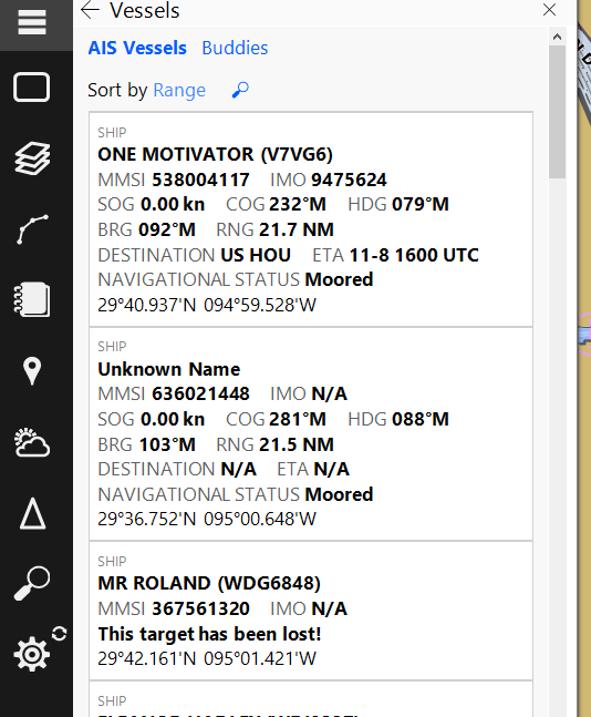
There is a “Sort By” option above the list of vessels and selecting “Range” will sort the vessels based on their proximity to your location.
Sorry - Where is the “sort by” option located?
It is not shown here, and right clicking on the target list, does not get a sort by option.
OK - I found it.
I was looking at the instrument panel, with an AIS radar, and AIS target list. That shows up on the right.
But, if you click on the triangle AIS target looking icvon on the left side, you get a different list that does have a sort by option.
Learned something new!
Sorry, I assumed that was the list you were referring to… Glad you were able to learn of its existence!
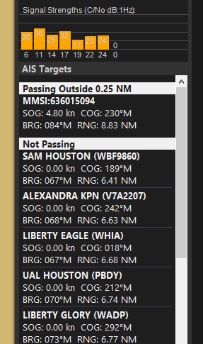
The list in the instrument panel was designed to help prioritize vessels that you are more likely going to have to consider. It does that by splitting vessels into groups like “dangerous”, “passing inside 0.25 NM”, “passing outside 0.25 NM”, and “not passing”. The first three groups are sorted by TCPA which means they are in the order in which you will be passing them and the last group is sorted by the distance between you and that vessel.
Hopefully the Tracking browser will work for your use case as we feel adding sorting options to the list in the instrument panel would effectively change its purpose or at least require disabling the grouping feature.
I did not ask the original question.
The way that the instrument panel displays AIS targets in groups works for me. I’ve moved my boat maybe 1,000 miles in the Western Rivers and Gulf ICW looking at AIS data on Coastal Explorer - seems totally useful and understandable at a glance with the way it is.
Robert
I have the same issue with the sorting order on the instrument panel. I’ve inquired for years if it could be changed to target range. I deliver boats all over on inland rivers and big harbors; it;s very helpful to quickly look and identify names that related easily to your position on the chart. The vectors and flashing color for CPA, get your attention enough to start tracking those vessels. I don’t want to constantly have to keep clicking to go to another popup to see those in close proximity. Plus in a busy bay or oilfield - having a danger vessel show up on top of list that is 12 miles away, then screen rearrange - very annoying.
We mainly move small commercial vessels that have various mfg’s of AIS equipment on board; all use sort by range on their display. Makes it very easy to get the vessels name before hailing for meeting instructions; especially at night, when sometimes it’s tough to read the name on the chart display.
A Miss River pilot introduced me to your program and have been using it ever since. You have the best display w ease for CPA than any other programs or plotters.
Kim Whitaker
Hello Kim,
First, I want to be sure that you are aware that we also have a commercial navigation product, Rose Point ECS. It has many features specific to inland use, such as mile-marker ETAs, cursor distance, that all use the river to calculate distances instead of as the crow flies calculations. Perhaps that product would suit your needs better.
If you are interested in learning more about it, you’ll want to contact Joe Sluka, our Commercial Marine Sales Director. He can be reached at his email address (joe@rosepoint.com), or you can call and ask for him.
425-605-0985
In any case, thank you for your feedback and we consider all feature requests.
I triple down on this request. Often times my AIS target list in the instrument panel rearranges so quickly that it is difficult to isolate the nearest targets (most important whilst underway). Being able to sort based on target range as opposed to CPA would be a great improvement to CE.
Zora Neale
One more comment on this. The ICW is a serpentine waterway in parts of Georgia and South Carolina. A list of AIS targets sorted by CPA in these areas is often little better than a random sorting - a boat traveling in my same direction (ICW North or South) in the opposing side of a waterway U can show up at the top of my CPA sorted list whereas a boat traveling in the opposite direction - and on a collision course with my vessel - in a waterway U shows up at the bottom of the CPA sorted list (we are traveling on more or less parallel paths). Give me a nearest target sort option…
Time to revisit this request - again. An option to sort AIS targets by range in the instrument panel would improve the functionality of CE. Any chance this change makes it into an upcoming release?
Zora Neale
100% Agreement - give me a sort by range. Not CPA. In the Western Rivers, where the waterway snakes in tight U bends or almost complete figure 8 - CPA is meaningless. A range sort would be FAR more useful.