When sailing in Northern Europe, I have been using Coastal Explorer for years along with nv raster charts.
Because of the obstacle and shallow water warnings, I would like to use vector charts instead.
For Germany and Scandinavia, the only vector maps available seem to be the C-MAP maps. Navionic is unfortunately not supported by CE.
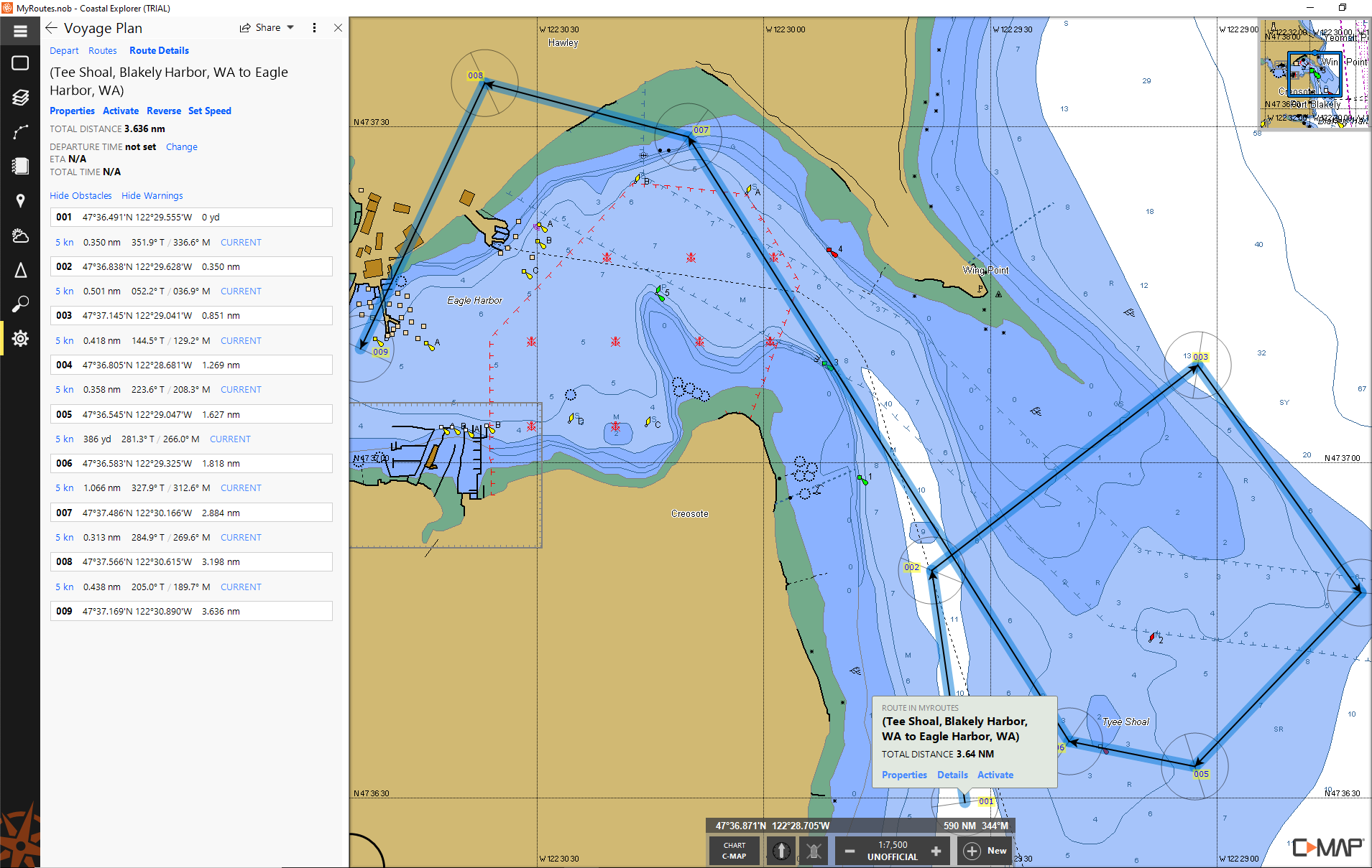
I used the C-MAP test maps available in the map store and created a route that went over shallow water, restricted areas, beacons, etc. There were no warnings in the route details.
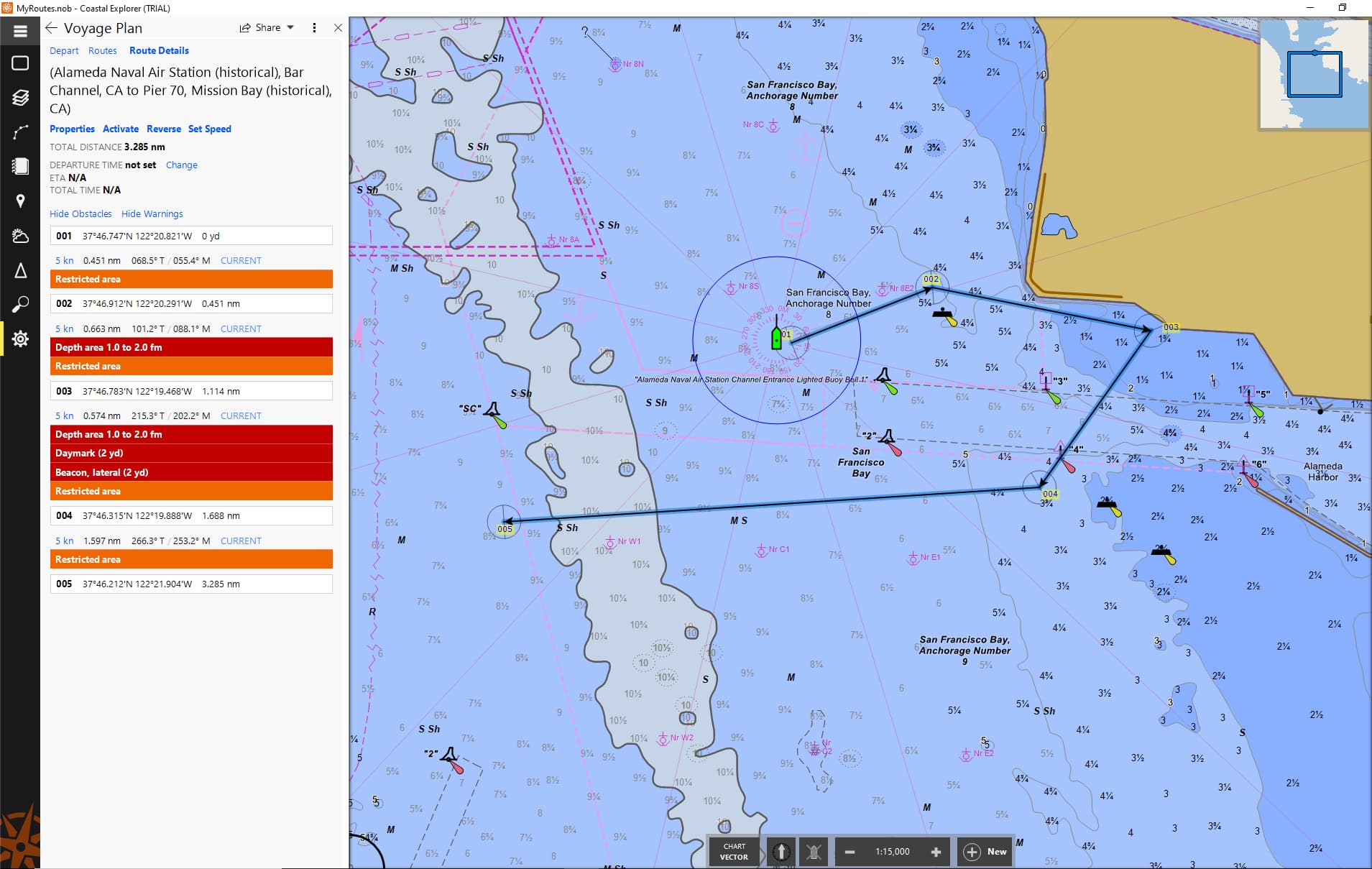
I did a similar test with NOAA charts and found that the warnings for shallow water, obstructions, restricted areas, etc. showed up perfectly in the Route Details tab.
What does this mean? Does CE not evaluate this information from the C-MAX maps or do these maps not cover this information ? I tested the C-MAP maps with TimeZero and got shallow water alerts though…
Please see the attached screenshots
Hello TrueBlue,
Obstacle detection does not work with C-MAP charts. We do not have the same level of access to the underlying data that we do with S-57 and S-63 charts. While C-MAP charts are a type of vector chart, for the purposes of obstacle detection they are similar to raster charts.
Also, please see Steven’s reply here regarding the unavailability of C-MAP charts (for purchase) at this time.
Would CE accept C-MAP NT/PC charts purchased from a local chart supplier ?
When C-MAP chart activation worked, it would get confused if a customer had some charts purchased from us and others purchased using a PC-Selector disk purchased from a vendor.
Also, PC-Selector disc C-MAP charts use the same licensing server so I doubt those would successfully activate right now.
You can try, but if you do have problems activating them, you would have to contact C-MAP customer support to work through the problems.
Steven, thank you very much for your information.
So for sailors from Europe, there seem to be no CE compatible vector chart with obstacle and shallow water alarm available.
That is a pity. ![]()
Strictly speaking, that’s not true. S-63 charts from AVCS (Admiralty Vector Chart Service), for example, are an encrypted form of S-57 vector chart (ENC). They are expensive, but you also have much finer control over which charts you purchase, so you aren’t necessarily forced to get a big region, but can pick and choose what you end up with, and that lets you be more strategic in what charts you get, making them potentially less expensive.
AVCS sells charts for pretty much the entire world, but they are oriented to commercial use, so you may not get as much detail for more off the beaten path locations, or only at larger scales.
When you buy S-63 charts, you must provide AVCS with your S-63 User Permit, which is unique for each Coastal Explorer machine you’re using, so you’d need to provide them with the S-63 User Permit for each machine you want to use them on, and if you change machines, you’d have to give AVCS the new systems Use Permit, which would probably cost a bit more.
This might be worth investigating for you, though.