A number of months ago the quality of Canadian Vector charts degraded. Cells have become unusable at larger scales. Search functions also stopped working. Is this a setting I have wrong or has licensing changed?
Raster charts also seem to be fading in quality and coverage. I paid for both Raster and Vector charts full suite for BC coast and now find areas where the charts are not adequately scaled.
Fergus, the Raster charts are discontinued as of Dec 2024 and are no longer available. Are you still having issues with the quality of Vector charts in BC?
That is a real shame the Rasters are discontinued. Is the that CHS or your decision? Raster charts are superior in many ways for geographical reference. ENCs make landmarks and island names very hard to find if they exist at all. Do they not use Raster charts to print paper charts? Are all paper charts now discontinued? I’m happy to chase this with CHS if you are not getting the data you need to build better charts. As an industry, I’d be very concerned with this. Push towards ECDIS means hydrographic data should be getting better, not worse.
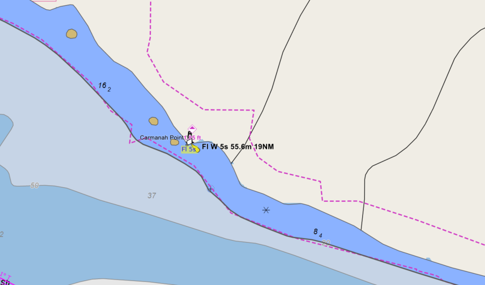
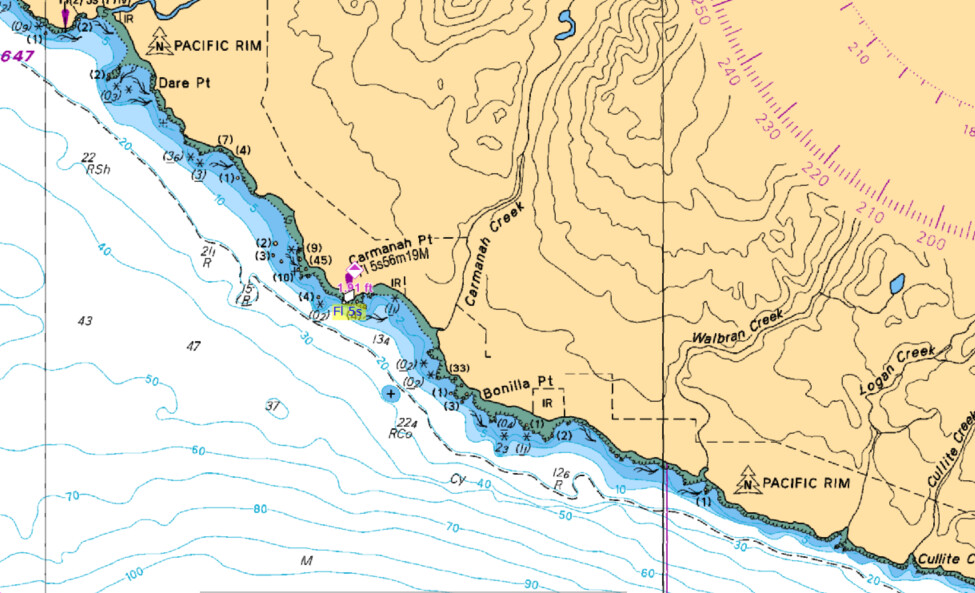
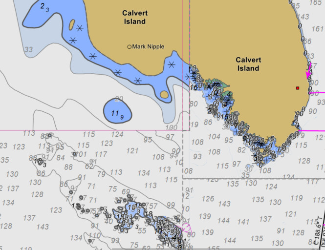
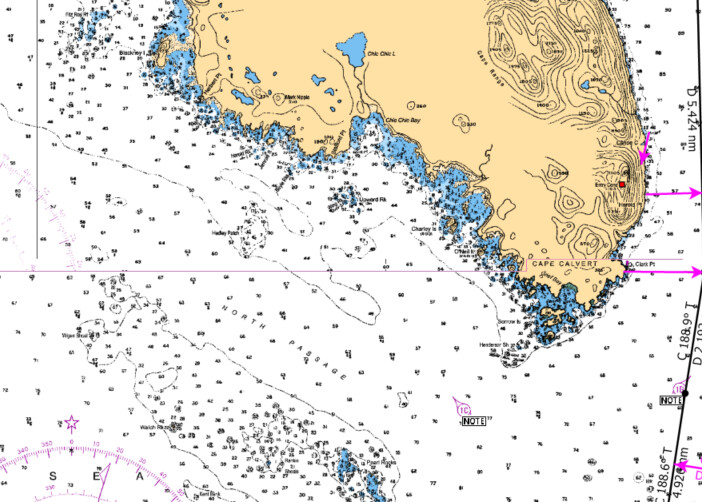
The ENCs are what I’m most concerned about. The quality is so low it would not satisfy ECDIS requirements. I’m not sure if the is CHS , NOAA or Rose Point. Below are some examples from the BC coast. These are primary shipping routes with commercial and small vessel traffic.
The first 2 examples show the difference in data available from Raster to Vector. No comparrison to the mariner. I have been sailing proffessionally all over the world for 25 years and Juan de Fuca straight now shows lower quality ENC data that the mexican coast in the late 90s. Basically a vague reference only hardly worth looking at hence why we needed the paper charts legally.
Am i missing something or is this a 9 month wait to confirm the quality of ENCs for BC are dangerously imprecise? Does Rose Point have any concerns here? Is this the best that CHS offers you. I dont want to be rude but I am a Master Mariner and I’m concerned about the quality of your charting software. I use this software for in depth study of the BC coast, and somthing is not up to quality.
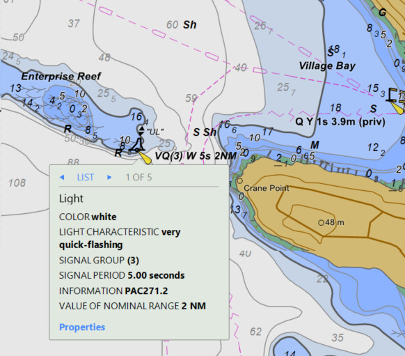
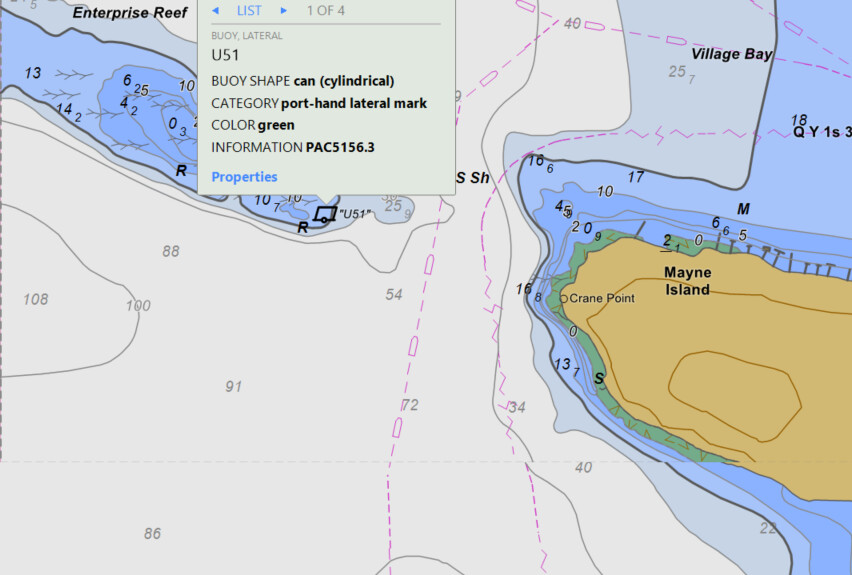
If this is CHS, I’m happy to discuss with them. I have found multiple moving bouys that change location with scale changes. That is dangerous! That does not satisfy ECDIS legality. This could put a ship on the rocks. The survey accuracy changes is dramitic as illustrated above. It make the transition zones and poorly illustrated areas (Juan De Fuca is well surveyed!) doubtful.
We have no control over the quality chart data and are confident that Coastal Explorer is drawing the charts as precisely as possible. If you want, you can report problems with CHS charts using this link: https://www.charts.gc.ca/help-aide/marep/index-eng.asp.
Thank you for getting back to me. That is unfortunate that CHS can’t do better. I would guess it would be advantageous if the software companies forwarded their concerns on ENC quality as you are the experts. I will follow up with them from the user standpoint. I’m curious if you find quality differences between NOAA and CHS?
What is also confusing is Rasters show higher quality and density of data than Vector charts of the same area. We have seen loss of data through missing geographical data for a long time. Further degradation is not going to help this transition.
Out of curiosity, what do ECDIS systems use for chart data in these areas? I can’t imagine data gaps and errors such as in the provided examples would be acceptable in professional practice. Is it that the recreational-grade chart data used for the CE packages is augmented or corrected in professional products?
Best regards and sincere respect from a 20-year CE user.
This is exactly the same data that is available to ECDIS systems. In fact, if an ECDIS were to use any other data, then it would no longer be considered a legal replacement for paper charts. If a vessel is required to use ECDIS and “adequate” ENC coverage is not available, then that vessel must also cary updated paper charts. However, a vessel that is required to use ECDIS is not likely to be in an area that doesn’t have good ENC coverage.
Part of the problem here is that these are not “recreational grade” charts, they are commercial grade charts. Recreational vessels go places commercial vessels don’t. When CHS started converting charts to ENC, priority was given to the charts covering most of the commercial traffic.
I really wish that CHS had not started discontinuing their raster charts until everything had been converted to ENC, but they did. Luckily they are making progress on filling the gaps and some of the problems illustrated above have been addressed. However, as far as I can tell, they have not published a schedule or even provided a status report, so it’s hard to say how long the rest will take.
FStewart: I am late to this discussion. Like you, I was concerned about moving from CHS Rasters to the ENC’s. It took me a while to transition, which I started in 2023. I have become convinced these charts are superior to the rasters and it all comes down to level of “Zoom”. You have to “wheel” in and out to see the details you want to see. I am now pretty much exclusively using vector charts.
WRT Rasters: be aware that the details you referenced on some of the rasters above are from very old charts are highly suspect and may be “out” by a hundred “yards” (or metres), or more. In whatever location you find yourself, the underlying “soundings” at their specific positions may be in error, regardless of whether you are in Raster mode or vector mode.
My biggest issue with the transition from Rasters has been the loss of land details, in particular land contours. Slowly, CHS is bringing these back, but only with certain “zooms”, so play around with that.
I can still switch back and forth between vector and raster charts to see if rasters provide more information. However the biggest issue I have is the quality of the information in specific locations of deficiency, particularly for example for the west coast of Haida Gwaii.
I would ask Coastal Explorer to continue to support the older rasters at least for the next few years.
Further to this, I would argue that rather than spend resources to bring older raster charts up to date, CHS should focus on whatever is necessary to provide more accurate information in those locations that are currently deficient.
WRT your comments concerning the Vector vs Raster comparisons in the vicinity of Cape Calvert. The raster charts in question are 3598 and 3792. According to the title block for 3598 the soundings were 1941-58, and for 3792 the sounding are 1958. Given these were undertaken pre-GPS, they are probably not accurate, although may be precise. That means at all soundings may be off by some amount consistent across the chart. I have encountered instances where these may be off up to 100 metres, for example Chart 3808 Juan Perez Sound, where the soundings and shoreline in Murchison Island Anchorage being off at least 30 meters. I watched the CHS survey vessel leave the anchorage with its AIS target sailing over a dry islet.
The most important issue, in my opinion, is the underlying accuracy of the sounding and shoreline information.